


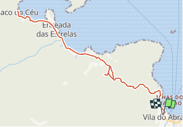
Ilha Gande: Abraao à Saco do Ceu

MathieuBourgois
Gebruiker

Lengte
16,1 km

Max. hoogte
229 m

Positief hoogteverschil
601 m
Km-Effort
24 km

Min. hoogte
0 m

Negatief hoogteverschil
601 m
Boucle
Ja
Datum van aanmaak :
2024-10-24 11:45:47.071
Laatste wijziging :
2024-10-24 11:46:25.994
5h28
Moeilijkheid : Medium

Gratisgps-wandelapplicatie
 SityTrail
IGN / Geografische instituten
SityTrail Plus
De wereld gaat voor u open
Over ons
Tocht Te voet van 16,1 km beschikbaar op Rio de Janeiro, Onbekend, Angra dos Reis. Deze tocht wordt voorgesteld door MathieuBourgois.
Beschrijving
16km
600D
Plaatsbepaling
Land:
Brazil
Regio :
Rio de Janeiro
Departement/Provincie :
Onbekend
Gemeente :
Angra dos Reis
Locatie:
Unknown
Vertrek:(Dec)
Vertrek:(UTM)
585090 ; 7440657 (23K) Z.
Opmerkingen